|
Conditions and route info
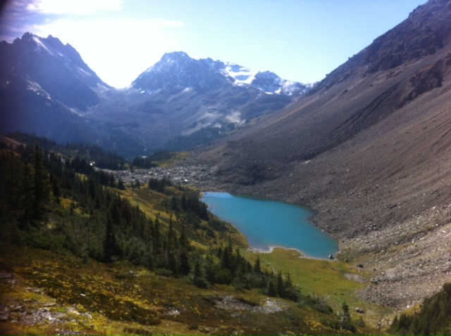
from a four day traverse of the northern Dogtooth range in the Purcell
mountains.
ACMG Hiking Guide
exam, Sept. 17 – 21, 2013
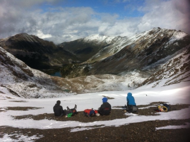
Mountain Travel & Conditions: We found seasonal fall
conditions with 5-10cm of new snow above 2300 meters from the low pressure
system that came in on Sept.
18th. Temperatures ranged from -4 to +11 degrees. Below 2300
meters rain and early morning frost made travel on lichen covered quartzite
tedious. We observed rockfall generated from melting snow as well as a size 1
point release on an easterly aspect at approximately 2700 meters. Freezing
levels were at 2300 meters, rising throughout the day. Up to 30cm of snow
on wind loaded slopes made travel slightly easier up scree bound
cols.
Route info: Nine candidates, and three instructors recently completed a four day traverse of the northern Dogtooth range in the Purcell mountains. All grid references are in NAD 83. On the first day we entered via Quartz Creek. The trailhead is about 6 km down the Quartz FSR just before a bridge crossing Quartz Creek. The initially steep trail is in decent condition but has a few trees down across the trail. The Lower Quartz Lake campground has several tent pads, picnic tables, and an outhouse, although they are situated quite close to one another.Two groups proceeded around Lower Quartz Lake on the west side – across a quartzite talus slope and then up to a wooded bench. The third group decided to traverse the talus slopes on the east side of the lake, and we all met in camp near a marshy drainage at G.R. 800967. Water supply was a non issue and there were good options for bear hangs near camp. On the second day, the three groups took diverging routes to our next campsite. Two groups ascended to Upper Quartz Lake by following the marshy creek to the base of the headwall below the lake and the worked up through the trees on a broad rib to the right of the outflow creek. Once at Upper Quartz, one group followed the obvious drainage at the back of the lake and then up till and talus slopes to the Quartz-Cirque col @ G.R. 814 956. Once at the col they took day packs up and summited the non-technical peak west of the col (Oldman Peak). The second group crossed the talus on the west side of the lake into a cirque due south of the lake. They climbed to the col at G.R. 813 954 which required ascending through a few cms of new snow that started at 2400m. Once at the col, we traversed talus slopes heading south for around 50m to avoid cliffs bands below, before dropping down to the valley on mostly soft, dirt trails. The third group headed south out of camp and followed a drainage up to a col @ G.R. 800 952. They then traversed SE for about 1 km to access another col @ 807 941. >From here they dropped into the Cirque drainage near a tarn and traversed down and west to access the rolling meadows. Once groups one and two had dropped down into the rolling meadows from their perspective cols, we proceeded down to the Cirque meadows. Group one dropped more directly to the valley floor, whereas group two traversed south higher before angling down to our campsite @ G.R. 826 936. Travel down was straightforward. We continued our southbound traverse of the Northern Dogtooth Range breaking our Cirque Meadows Camp (826935). We gained the Cirque-Lang Col (831925) on it’s East End traveling on soft scree then small talus. We easily descended to Lang Tarn (833915) on soft scree, continuing down meadows to the confluence of the Upper Lang Basins (841903) where desirable campsites were abundant. We began our climb to the Lang Rock Glacier, gained by a grassy ramp on its East side. Travel through limestone and slate moraines brought us to the Lang-Gorman Col (853885). A short descent provided a stunning alpine campsite (885880) with clear views of the Lake Louise and Lake O’Hara groups. On our final morning we descended to Gorman creek above Gorman Lake and gained a cairned trail to the Gorman-Holt Col (862873). We arranged a helicopter pick up from treeline meadows (868863) for our exit over the forests the Holt Basin.
_______________________________________________ These observations and opinions are those of the person who submitted them. The ACMG and its members take no responsibility for errors, omissions, or lapses in continuity. Conditions differ greatly over time and space due to the variable nature of mountain weather and terrain. Application of this information provides no guarantee of increased safety. Do not use the Mountain Conditions Report as the sole factor in planning trips or making decisions in the field. See http://acmg.ca/mcr for more information. See http://informalex.org/subscribe.shtml#unsubscribe to remove your name from this list. |
| Previous by Date: | [MCR] Glaciers in Glacier National Park, Public Mountain Conditions Report |
|---|---|
| Next by Date: | [MCR] Floe Lake, Kootenay National Park Sept 21-22, Public Mountain Conditions Report |